- Introduction to Instagram-Worthy Photos from Northern Hokkaido
- Wakkanai’s White Road
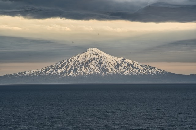
- Rishiri Fuji
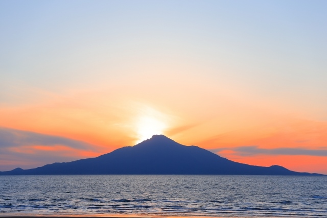
- Diamond Rishiri
- Rebun Island
- Mount Rishiri
- Cape Sukoton
- Biei
- Hills of Biei
- Rainbow and Biei Flower Fields
- Fudo Falls
- Shirahige Falls
- Furano Lavender Fields
- Mount Tokachi
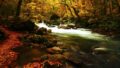
- Kanayama Lake Park Autumn Leaves
- Jet Coaster Road
- Filming Location of “From the North Country” Drama
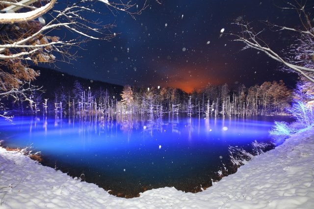
- Shirogane Blue Pond
- Shirogane Blue Pond Illumination
Introduction to Instagram-Worthy Photos from Northern Hokkaido
In Wakkanai, the northernmost town of Japan, there is a “White Road,” a footpath course made of scallop shells that stretches about 3 kilometers. From this pure white road, you can see wind turbines, Sakhalin, and Mt. Rishiri. Off the coast of Wakkanai, Rishiri Island and Rebun Island float. The symbol of Rishiri Island, Rishiri Fuji, is known for its perfect conical shape, and the “Diamond Rishiri” that can be seen twice a year shines like a jewel. Adjacent to Rishiri Island, Rebun Island is known as the “Floating Island of Flowers,” with seven walking trails where colorful alpine plants bloom. At “Cape Sukoton,” you can enjoy the clear sea known as “Rebun Blue,” a landscape that looks like a painting. The inland area of Biei in Hokkaido features a patchwork-like rural landscape with beautiful rolling hills that captivate visitors. Landmarks such as “Ken and Mary’s Tree” and “Seven Stars Tree” dot the area, offering picturesque views wherever you look. Furthermore, the “Blue Pond” in Shirogane is a magical place where the blue, transparent water shows various expressions depending on the season and weather. Famous for the TV drama “From the North Country,” Furano is also not to be missed. Particularly, the lavender fields of “Farm Tomita,” which boast the largest scale in Japan, are spectacular. These tourist spots in northern Hokkaido enchant visitors with their natural beauty and diverse charms, making them ideal places to capture stunning, Instagram-worthy scenery.
Wakkanai’s White Road
The “White Road” is part of a footpath course in Wakkanai, made using scallop shells, stretching about 3 kilometers. “Footpath” refers to a small path originating in the UK, designed for walking (Foot) while enjoying the natural scenery (Path) of the area. This “White Road” was first created in 2011, and its beautiful scenery has become a popular topic on social media. From this road, you can enjoy a 360-degree view of 57 wind turbines, Sakhalin, and Mt. Rishiri, making it a popular tourist spot.

Instagram Worthiness: ★★★★★
Photography Opportunity: Difficult in Winter
Location Information: ▶Map, Hours, Routes
Transportation Information: Car Required
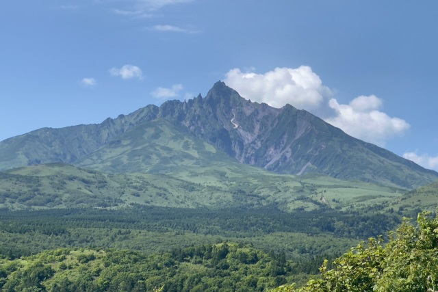
Rishiri Fuji
Mount Rishiri, a 1,721-meter mountain on Rishiri Island, is also known as “Rishiri Fuji” because of its beautiful shape resembling Mount Fuji. From the summit, you can enjoy a 360-degree panoramic view, overlooking Rishiri Island, Rebun Island, and Hokkaido.
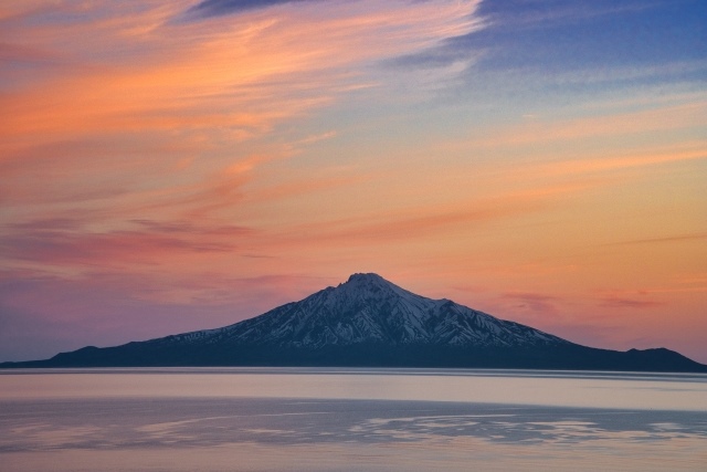
Instagrammable: ★★★★★
Photo Opportunities: All seasons
Location Information: ▶Map,Hours,Routes
Transportation Information: Limited public transportation
Diamond Rishiri
You can witness a view similar to “Diamond Fuji,” where the sunset aligns perfectly with the summit of Mount Rishiri, twice a year in April and August. The most beautiful view is recommended from the Wakasanai area on the outskirts of Wakkanai. By checking the sun’s position and moving by car, you can find the optimal spot where the sun aligns directly above Mount Rishiri.
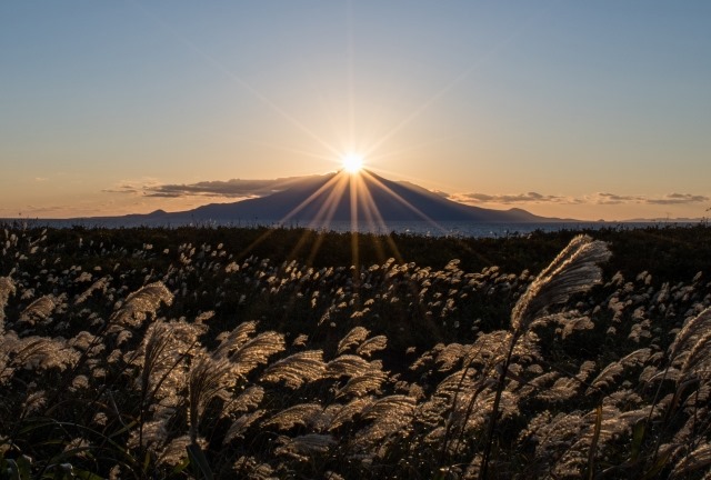
Instagrammable: ★★★★★
Photo Opportunities: Rare
Location Information:▶Map,Hours,Routes
Transportation Information: Limited public transportation
Rebun Island
Rebun Island is the northernmost island in Japan, located 60 kilometers west of Wakkanai City. Known as the “Floating Island of Flowers,” about 300 species of alpine plants bloom on the island. There are seven walking trails, and since there are no bears or snakes, you can safely enjoy your hike.
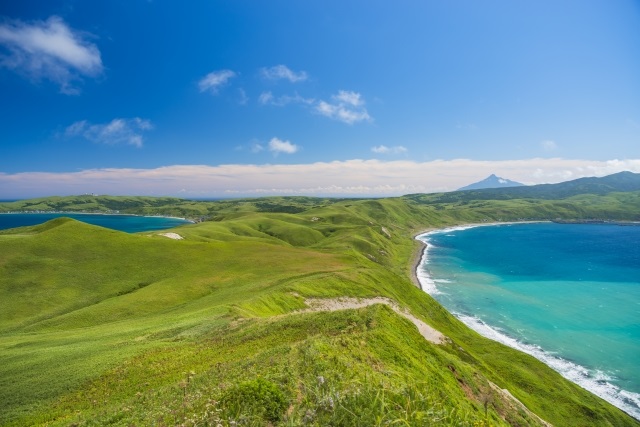
Instagrammable: ★★★★★
Photo Opportunities: Difficult during winter
Location Information:▶Map,Hours,Routes
Transportation Information: Car needed
Mount Rishiri
The name “Rishiri” comes from the indigenous Ainu language, meaning “tall island mountain.” There are two hiking courses, with the “Oshidomari Course” recommended for beginners.
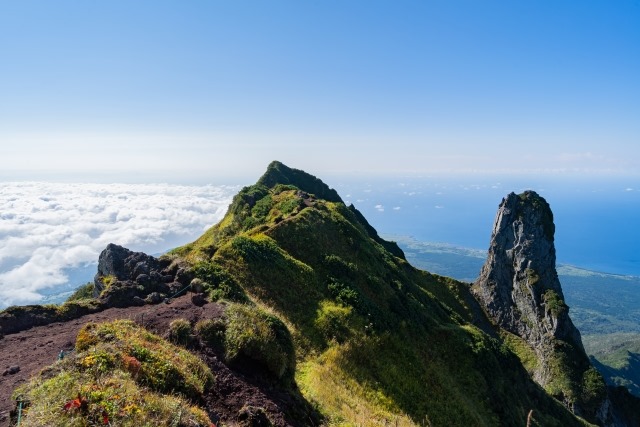
Instagrammable: ★★★★★
Photo Opportunities: Difficult during winter
Location Information:▶Map,Hours,Routes
Transportation Information: Hiking on foot
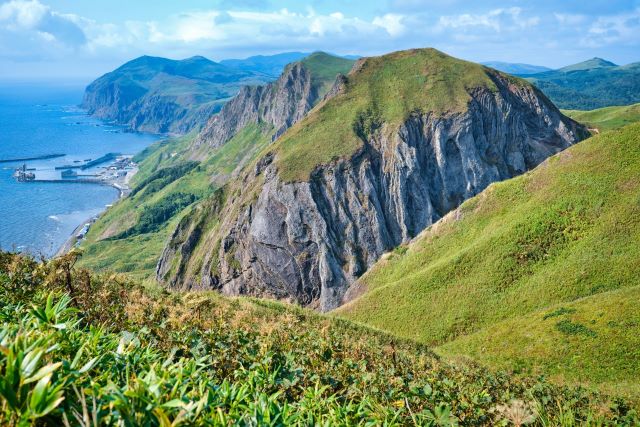
Cape Sukoton
This cape on Rebun Island is a popular tourist spot and one of the highlights of exploring the island. The sea in the beautiful bay is exceptionally clear, changing color with the sunlight, allowing you to enjoy the “Rebun Blue” jade-colored sea. Additionally, you may be lucky enough to spot seals along the coastline.
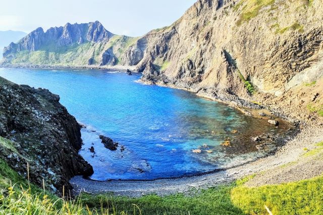
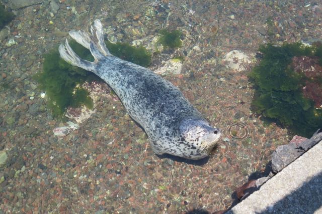
Instagrammable: ★★★★★
Photo Opportunities: Difficult during winter
Location Information:▶Map,Hours,Routes
Transportation Information: Car needed
Biei
Biei features famous trees such as “Ken and Mary Tree” and “Seven Stars Tree” scattered across the landscape. From the Northwest Hill Observation Park, you can enjoy a panoramic view of the beautiful hills of Biei and the Tokachi Mountain Range.
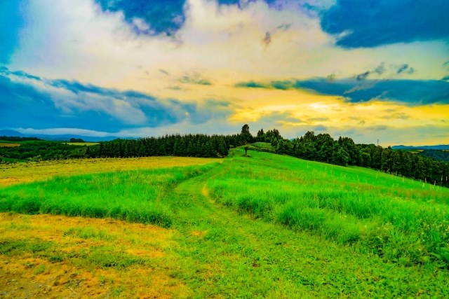
Hills of Biei
The hills of Biei are divided into two areas: Panorama Road and Patchwork Road. Patchwork Road is particularly known for its scenery resembling a patchwork quilt with fields of potatoes and wheat, and it has been featured in many commercials and product packaging.
Instagrammable: ★★★★★
Photo Opportunities:Late July to Late September
Location Information:▶Map,Hours,Routes
Transportation Information: Car needed
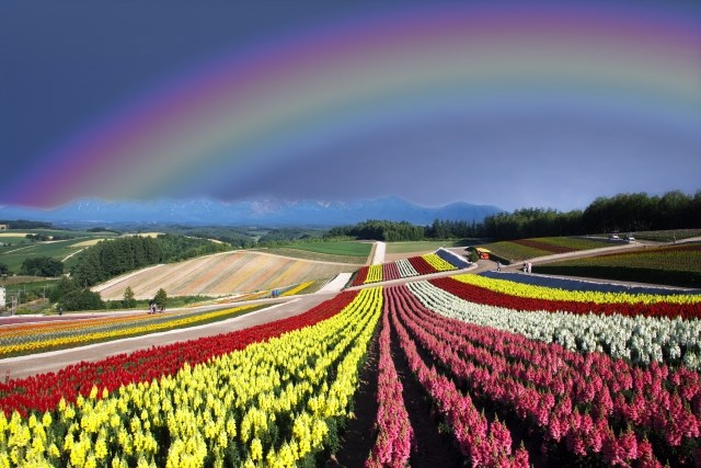
Rainbow and Biei Flower Fields
Biei is also known as the “Town of Rainbows” where rainbows frequently appear. Especially, the double rainbow, considered a symbol of happiness, is said to have treasures at both ends according to legend.
Instagrammable: ★★★★★
Photo Opportunities: Late July to Late September
Location Information:▶Map,Hours,Routes
Transportation Information: Car needed
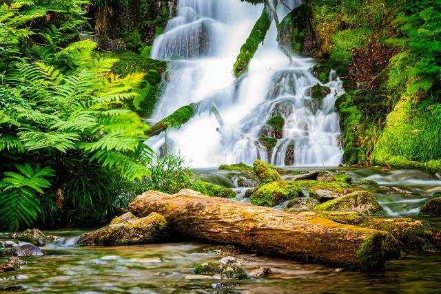
Fudo Falls
Fudo Falls is about a 25-minute drive from JR Biei Station and a 20-minute walk from Shirogane Onsen. This waterfall, approximately 25 meters tall, is very impressive due to its height and depth.
Instagrammable: ★★★★★
Photo Opportunities: Mid-October to Late October
Location Information:▶Map,Hours,Routes
Transportation Information: Car needed
Shirahige Falls
Shirahige Falls is located in the Shirogane Small Box area of Biei River. The waterfall is 40 meters wide and 30 meters high. The thin streams of water flowing down from the rocks look like a white beard, which is how it got its name.
Instagrammable: ★★★★★
Photo Opportunities: Late September to Mid-October
Location Information:▶Map,Hours,Routes
Transportation Information: Car needed
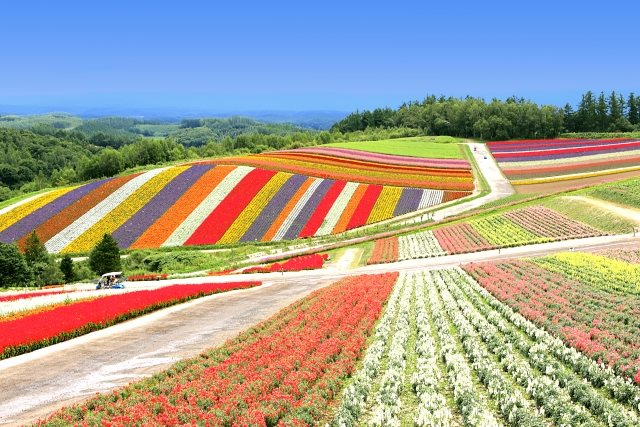
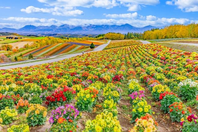
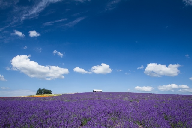
Furano Lavender Fields
In summer, Furano’s fields are covered in purple lavender, and in winter, you can see the magnificent snow-covered mountains. The area is also known as the setting for the famous Fuji TV drama “From the North Country.” Lavender has been cultivated in this area since around 1948, and at its peak, there were fields spanning 130 hectares. Particularly, the lavender fields at Farm Tomita are among the largest in Japan, offering stunning views of the lavender slopes and the beautiful rural landscape of Furano along with the Tokachi Mountain Range.
Instagrammable: ★★★★★
Photo Opportunities: Late June to Mid-August
Location Information:▶Map,Hours,Routes
Transportation Information: Car needed
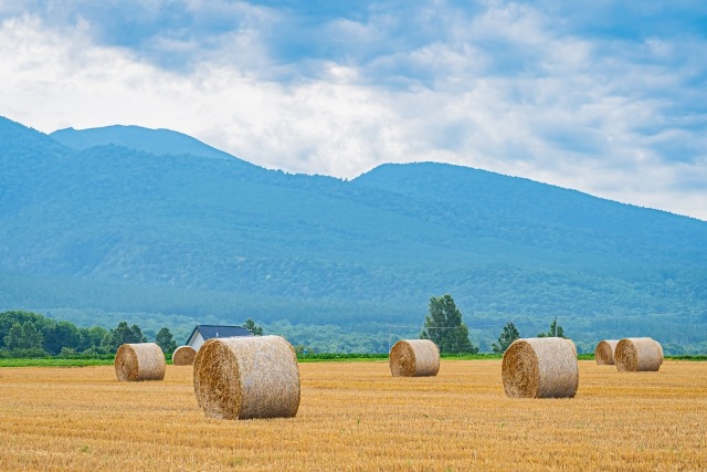
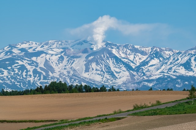
Mount Tokachi
This mountain range was formed over approximately 2.5 million years. It is also a famous volcano and has erupted several times in the past. The most recent eruption was in 1988, causing the closure of Shirogane Onsen at the foot of the mountain and temporarily banning climbing. Climbing was reopened in 1990, but the terrain and climbing routes change with each eruption, so caution is needed. The paths can be unclear due to volcanic ash, so climbers should be very careful.
Instagrammable: ★★★★★
Photo Opportunities: All seasons
Location Information:▶Map,Hours,Routes
Transportation Information: Car needed
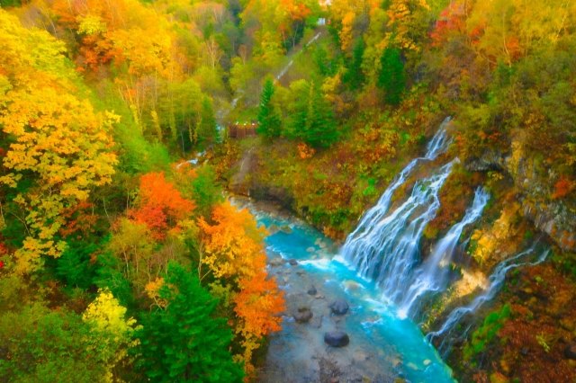
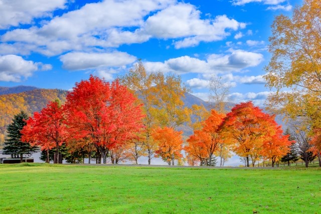
Kanayama Lake Park Autumn Leaves
Kanayama Lake is an artificial lake with one of the largest water storage capacities in Hokkaido. The surrounding vegetation and primeval forests create a beautiful landscape similar to that of a natural lake. Especially from mid to late October, the mountains surrounding the lake are adorned with beautiful autumn leaves, offering a vibrant and colorful scenery, making it a recommended visit.
Instagrammable: ★★★★★
Photo Opportunities: Mid-October to Late October
Location Information:▶Map,Hours,Routes
Transportation Information: Car needed
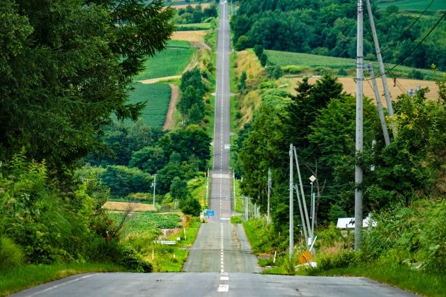
Jet Coaster Road
Kamifurano has a straight road with steep ups and downs known as “Jet Coaster Road.” This road continues for about 2.5 kilometers, offering beautiful views of hills and rural landscapes, making it a recommended drive to enjoy the scenery. It can be challenging to find via car navigation, so it’s best to use Route 237 from Biei to Furano. There are signs along the way, so be sure not to miss them.
Instagrammable: ★★★★★
Photo Opportunities: All seasons
Location Information:▶Map,Hours,Routes
Transportation Information: Car needed
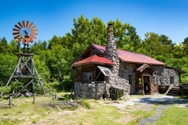
Filming Location of “From the North Country” Drama
The TV drama “From the North Country,” set in Furano Town and aired in 1980, became a popular show featuring the beautiful nature and family stories. The house built by the protagonist Goro by himself is a spot worth visiting for fans of the drama and nature enthusiasts.
Instagrammable: ★★★★★
Photo Opportunities: All seasons
Location Information:▶Map,Hours,Routes
Transportation Information: Car needed
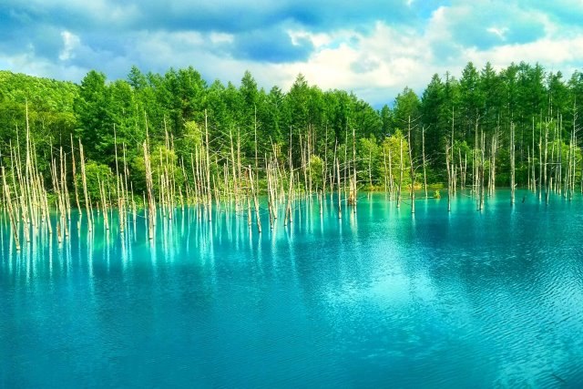
Shirogane Blue Pond
The Blue Pond is a famous tourist spot known for its blue-colored water. The reason for the blue appearance is the combination of aluminum-containing water from the hot spring town and sunlight. The charm of the Blue Pond lies in its changing blue color, from emerald green to light blue and milky blue, depending on the season, weather, time of day, and angle.
Instagrammable: ★★★★★
Photo Opportunities: All seasons
Location Information:▶Map,Hours,Routes
Transportation Information: Car needed
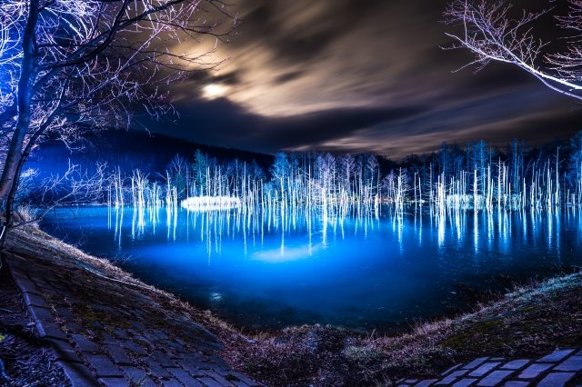
Shirogane Blue Pond Illumination
The Blue Pond is illuminated from November 1st to April 30th, but from December to early April, the blue water surface may not be visible due to snow. This event features various lighting patterns over approximately 10 minutes, telling a single story, allowing visitors to enjoy their favorite moments.
Instagrammable: ★★★★★
Photo Opportunities: November to April
Location Information:▶Map,Hours,Routes
Transportation Information: Car needed