- Introduction to Instagrammable Photos from Southern Hokkaido
- Niseko Ski Resorts
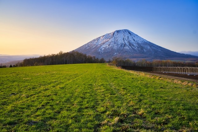
- Diamond Mount Yotei
- Niseko Ostrich Farm
- Fukidashi Park
- Mishima’s Shibazakura
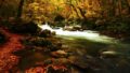
- Autumn Leaves at Shinsen-numa
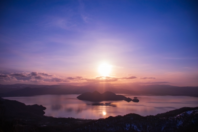
- Lake Toya
- Mount Usu
- Showa-shinzan
- Mount Yotei
- Sobetsu Falls
- 1977 Volcanic Heritage Park
- Ukimido Park
- Hakodate
- Night View of Hakodate
- Hachimanzaka
- Goryokaku
- Autumn Leaves at Kosetsuen
- Unkai Night View
Introduction to Instagrammable Photos from Southern Hokkaido
Niseko in southern Hokkaido is a world-famous ski resort known for its beautiful snow scenery and powder snow. Capturing the contrast of the vast snowfields and blue sky while enjoying skiing or snowboarding is exceptional. Additionally, Diamond Mount Yotei, as seen from Niseko, shines like a jewel when illuminated by the sunrise or sunset, providing an excellent photo opportunity for photographers.
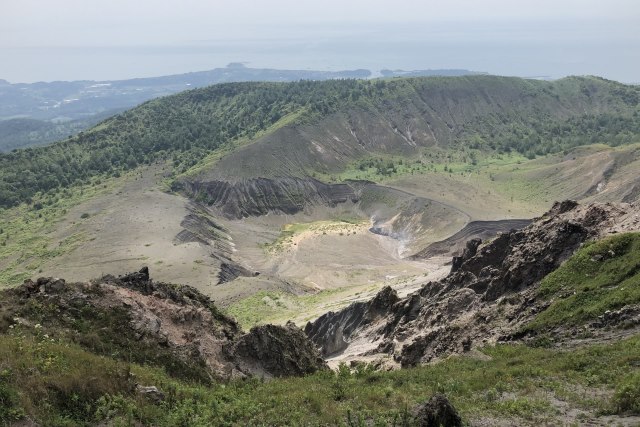
Lake Toya is another must-see spot. The seasonal landscapes reflected on the lake’s surface are all beautiful, especially during the autumn foliage season when the lakeshore is dyed in red and yellow, adding to its charm. From the nearby Mount Usu, you can get a panoramic view of Lake Toya. The volcano heritage park created by the 1977 eruption also serves as a popular photo spot, showcasing the power of history and nature.
A representative scenic point of this region is the night view of Hakodate. Known as one of the world’s three greatest night views, Hakodate’s nightscape is particularly enchanting when shrouded in a sea of clouds. The sight of the city lights floating in the cloud sea as seen from Mount Hakodate gives a sense of being in another world. Goryokaku, Japan’s first Western-style fortress, also offers breathtaking scenery during the cherry blossom season. The fully bloomed cherry blossoms and the star-shaped moat create a stunning view, especially at night when the illuminated cherry blossoms are beautifully reflected.
4o
Niseko Ski Resorts
During the winter season, the “Niseko United Shuttle Bus” operates, connecting the representative ski resorts of Niseko (Niseko Annupuri International Ski Area, Niseko Village, Niseko Tokyu Grand Hirafu, and Niseko HANAZONO Resort).
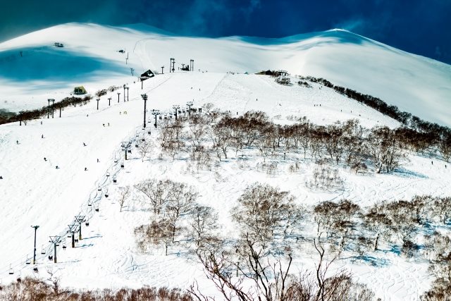
Instagrammable: ★★★★★
Photo Opportunities: Winter
Location Information:▶Map,Hours,Routes
Transportation Information: Frequent public transportation
Diamond Mount Yotei
“Diamond Mount Yotei” is a special phenomenon where the summit of Mount Yotei aligns with the setting sun, making it shine like a diamond. This spectacular view can only be seen a few days a year. The best viewing spots are on the eastern side of Mount Yotei, especially around Rusutsu Resort Golf 72, Kimobetsu Town, and Takara Farm. The optimal period is from May 20 to June 5, from just before 6 PM to past 6:30 PM.
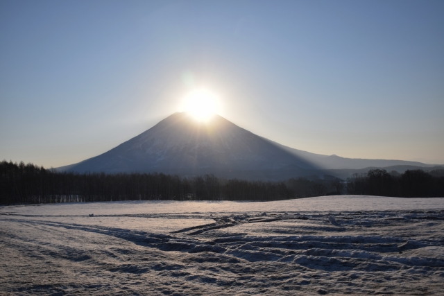
Instagrammable: ★★★★★
Photo Opportunities: May 20 – June 5
Location Information:▶Map,Hours,Routes
Transportation Information: Car needed
Niseko Ostrich Farm
Located a 10-minute drive from JR Niseko Station, the ostrich farm raises both cows and ostriches. Though native to Africa, ostriches are surprisingly resilient to cold. The farm also sells processed ostrich products.
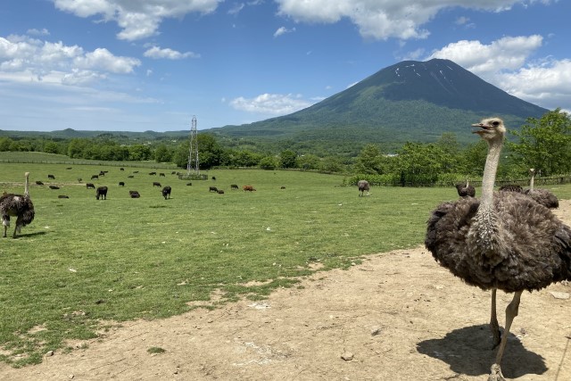
Instagrammable: ★★★★★
Photo Opportunities: All seasons
Location Information:▶Map,Hours,Routes
Transportation Information: Car needed
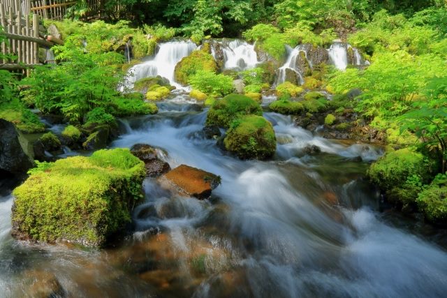
Fukidashi Park
Rain and snow that fall on Mount Yotei become groundwater, which springs up from the park at a rate of about 80,000 tons per day. The park has easy walking paths and an observation deck, with nearby hot spring facilities.
Instagrammable: ★★★★★
Photo Opportunities: All seasons
Location Information:▶Map,Hours,Routes
Transportation Information: Car needed
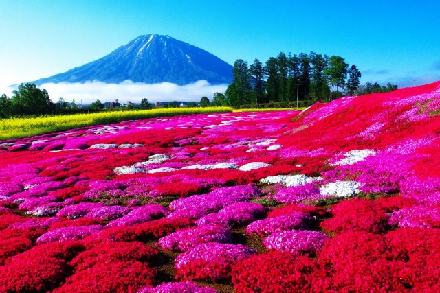
Mishima’s Shibazakura
A recommended photo spot in the Niseko area is “Mishima’s Shibazakura.” This 4,000 square meter garden is owned by Mr. Mishima, who lives in Kutchancho. Unlike regular cherry blossoms, this ground-covering perennial plant blooms in cherry pink from late May to June each year.
Instagrammable: ★★★★★
Photo Opportunities: Late May – June
Location Information:▶Map,Hours,Routes
Transportation Information: Car needed
Autumn Leaves at Shinsen-numa
A mysterious marsh located 35 minutes by car from JR Niseko Station, it becomes especially enchanting in autumn when the fall foliage is reflected on the water’s surface. The best viewing period is from late September to early October.

Instagrammable: ★★★★★
Photo Opportunities: Late September – Early October
Location Information:▶Map,Hours,Routes
Transportation Information: Car needed
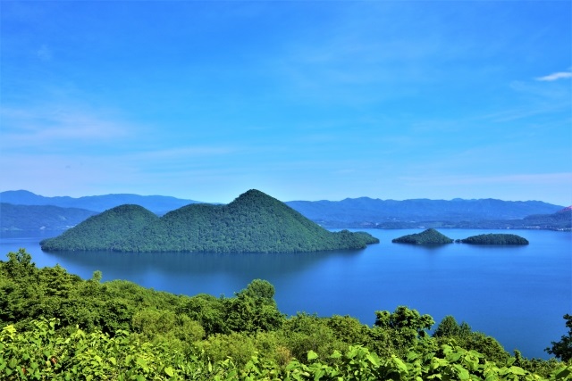
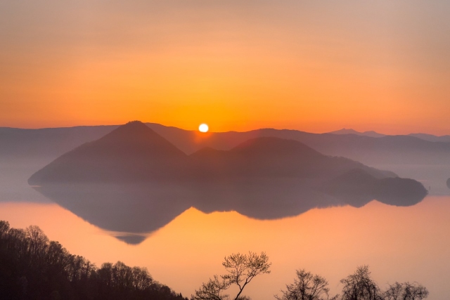
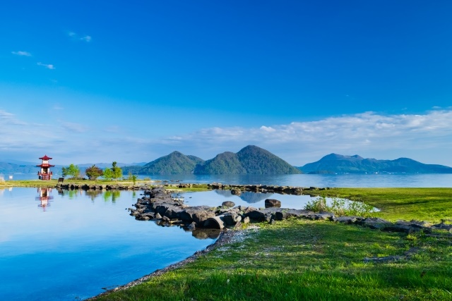
Lake Toya
Lake Toya is a caldera lake formed by a massive eruption about 110,000 years ago, caused by the collapse of pyroclastic flow sources. It is the sixth deepest lake in Japan, with the fifth highest transparency nationwide. The lake covers an area of about 7,000 hectares, forming the beautiful center of the national park in this region.
Instagrammable: ★★★★★
Photo Opportunities: All seasons
Location Information:▶Map,Hours,Routes
Transportation Information: Car needed
Mount Usu
Mount Usu was formed around 20,000 years ago, with its current shape resulting from a landslide 7,000-8,000 years ago. Four eruptions were observed in the 20th century. By taking the Mount Usu Ropeway and walking along the trails, you can see the crater formed by the 1977 eruption. This active volcano offers a close-up experience of nature’s power.
Instagrammable: ★★★★★
Photo Opportunities: All seasons
Location Information:▶Map,Hours,Routes
Transportation Information: Car needed
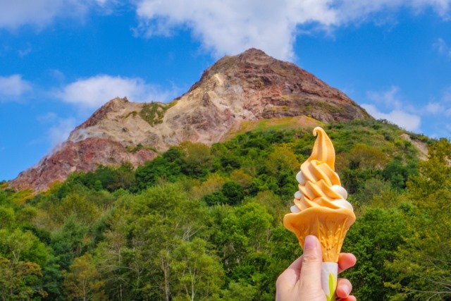
Showa-shinzan
In 1943, a volcanic explosion in a wheat field caused the ground to rise over four months, forming the 398-meter-high Showa-shinzan. To this day, it emits smoke, allowing visitors to experience the energy of the earth up close.
Instagrammable: ★★★★★
Photo Opportunities: All seasons
Location Information:▶Map,Hours,Routes
Transportation Information: Car needed
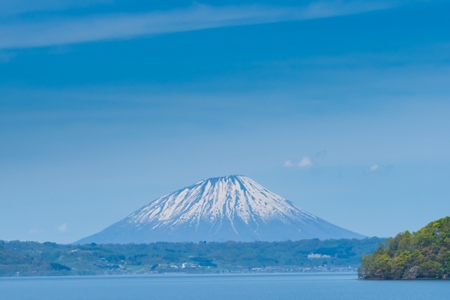
Mount Yotei
Mount Yotei stands at an altitude of 1,898 meters and is a representative mountain of Hokkaido. This beautiful volcano, resembling Mount Fuji, has a crater about 2 km in diameter at its summit and is also called Ezofuji. The mountain hosts over 100 species of alpine plants and is home to more than 130 species of wild birds.
Instagrammable: ★★★★★
Photo Opportunities: All seasons
Location Information:▶Map,Hours,Routes
Transportation Information: Car needed
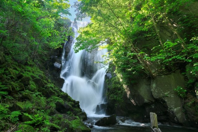
Sobetsu Falls
This waterfall, with a drop of about 18 meters, is the only outlet of Lake Toya, creating a powerful sightseeing spot. Its name derives from the Ainu language, meaning “river of the waterfall.” The trail to the waterfall includes tables and chairs, and the walking path offers beautiful scenery that changes with the seasons.
Instagrammable: ★★★★★
Photo Opportunities: All seasons
Location Information:▶Map,Hours,Routes
Transportation Information: Car needed
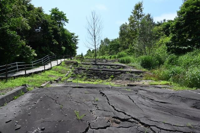
1977 Volcanic Heritage Park
The 1977 Volcanic Heritage Park preserves the town destroyed by volcanic activity from Mount Usu. The park aims to pass on the legacy of the volcanic damage to future generations, allowing visitors to experience the harshness of nature firsthand.
Instagrammable: ★★★★★
Photo Opportunities: All seasons
Location Information:▶Map,Hours,Routes
Transportation Information: Car needed
Ukimido Park
Ukimido Park is a popular spot with a scenic view that appears to float on the lake’s surface. Especially from late April to May, the cherry blossoms are in full bloom. The park paths are paved with stones, so caution is needed while walking.
Instagrammable: ★★★★★
Photo Opportunities: All seasons
Location Information:▶Map,Hours,Routes
Transportation Information: Car needed
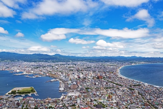
Hakodate
Hakodate, the gateway to Hokkaido, is an attractive city known for its beautiful night views, the historical site of the Meiji Restoration, Goryokaku, and its stunning seasonal scenery.
Instagrammable: ★★★★★
Photo Opportunities: All seasons
Location Information:▶Map,Hours,Routes
Transportation Information: Frequent public transportation
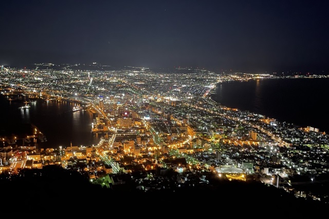
Night View of Hakodate
The night view of Hakodate city from Mount Hakodate is considered one of Japan’s three great night views. Known as the “million-dollar night view,” the observation deck offers views of Tsugaru Strait and Hakodate Bay. The ropeway provides a scenic ride to the summit, operating at 10-minute intervals, with a ride time of just 3 minutes.
Instagrammable: ★★★★★
Photo Opportunities: All seasons
Location Information:▶Map,Hours,Routes
Transportation Information: Frequent public transportation
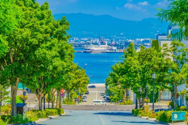
Hachimanzaka
“Hachimanzaka” is a popular tourist spot in Hakodate alongside the night view from Mount Hakodate. Named after the Hakodate Hachimangu Shrine that once stood there, this beautiful slope has stairs with handrails on the sidewalk and road heating in winter for safe walking. The once winding path now stretches straight towards the sea, offering views of the Masu-maru memorial ship moored in the port.
Instagrammable: ★★★★★
Photo Opportunities: All seasons
Location Information:▶Map,Hours,Routes
Transportation Information: Frequent public transportation
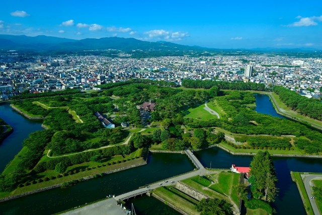
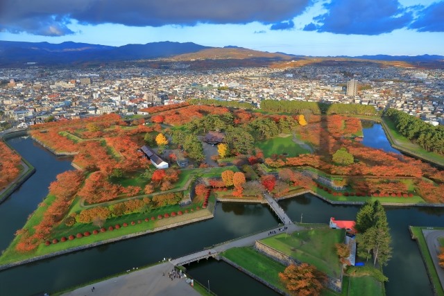
Goryokaku
Goryokaku, a star-shaped fort built in Hakodate at the end of the Edo period, is a rare sight in Japan. Known as the site of the Hakodate War between the new government army and the former shogunate forces, most of the buildings inside the fort were demolished and repurposed as an army training ground during the Meiji era. In 1914, it was opened to the public as Goryokaku Park, and in 1964, the 60-meter-tall Goryokaku Tower was built next to it.
Instagrammable: ★★★★★
Photo Opportunities: All seasons
Location Information:▶Map,Hours,Routes
Transportation Information: Frequent public transportation
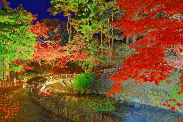
Autumn Leaves at Kosetsuen
Kosetsuen in Yunokawa Onsen was built as a villa by a prominent merchant in 1898. Known for its autumn foliage, the illuminated autumn leaves event held from late October to early November is impressive.
Instagrammable: ★★★★★
Photo Opportunities: Late October – Early November
Location Information:▶Map,Hours,Routes
Transportation Information: Frequent public transportation
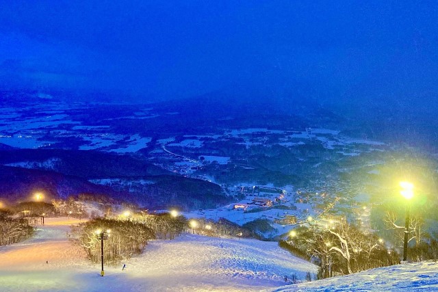
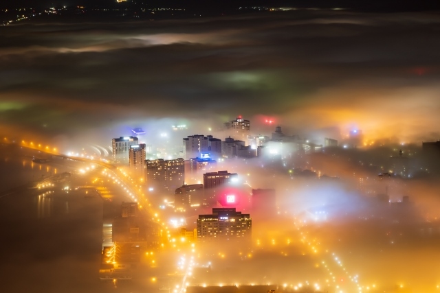
Unkai Night View
A rare moment when clouds formed over the Tsugaru Strait cover Hakodate’s cityscape, creating a fantastical “unkai night view” along with the nightscape. This phenomenon occurs a few times a year, mainly in June. Many photography enthusiasts gather at the summit of Mount Hakodate to capture this precious moment.
Instagrammable: ★★★★★
Photo Opportunities: June
Location Information:▶Map,Hours,Routes
Transportation Information: Frequent public transportation