- Introduction to Instagrammable Photos in Kagoshima Prefecture
- Sakurajima
- Eruption of Sakurajima
- Buried Torii of Kurokami
- Sakurajima Daikon
- Dawn at Sakurajima
- Diamond Sakurajima
- Tenmonkan
- Chiran Peace Museum
- Kirishima Shrine
- Kagoshima Shrine
- Kaimondake
- Ibusuki Onsen
- Tanegashima
- Amami Oshima
- Kakeroma Island
- Tokunoshima
- Yoron Island
- Okinoerabu Island
- Yakushima
- Jomon Sugi
- Wilson Stump
- Shiratani Unsuikyo
- Nagata Inakahama
- Senjin Falls
- Forest of Princess Mononoke
- Okawa Falls
Introduction to Instagrammable Photos in Kagoshima Prefecture
Kagoshima Prefecture offers not only historical shrines such as Sakurajima, Kirishima Shrine, and Ibusuki Onsen but also the beautiful white sand beaches and subtropical mangrove forests of the southern islands like Tanegashima, Amami Oshima, and Yoron Island, allowing you to enjoy a resort atmosphere.
Sakurajima
Sakurajima is an active composite volcano located in Kagoshima Bay and is considered a symbol of Kagoshima. This volcano spans about 12 km east to west and about 10 km north to south, with a circumference of about 55 km and an area of approximately 77 km², standing 1,117 meters tall. Formerly an island, it became connected to the Osumi Peninsula during the major eruption of 1914.
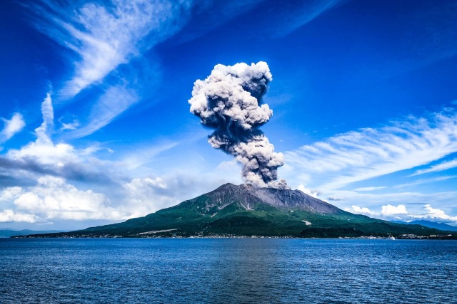
Instagram Worthiness:★★★★★
Photography Opportunity: All seasons
Location Information: ▶Map, Hours, Routes
Transportation Information: 15 minutes by ferry from Kagoshima Port ▶Timetable
Eruption of Sakurajima
Sakurajima is a relatively young volcano, formed after a massive eruption around 29,000 years ago. That eruption was about a million times the scale of the current eruptions of Sakurajima, covering the entire prefecture with a 60-meter-thick layer of volcanic ash. The pyroclastic flows buried mountains and valleys, creating a flat terrain. Eruptions resumed around 26,000 years ago, forming the current Sakurajima. It remains highly active today and is also a popular tourist destination. The Sakurajima Visitor Center offers insights into the history of the volcano and its geological changes. The region’s nature and history are closely linked to the ancient massive eruptions.
Instagram Worthiness:★★★★★
Photography Opportunity: All seasons
Location Information: ▶Map, Hours, Routes
Transportation Information: 15 minutes by ferry from Kagoshima Port ▶Timetable
Buried Torii of Kurokami
During the 1914 eruption of Sakurajima, the Kurokami area was buried in volcanic ash and pumice. The torii gate of Kurokami Shrine was buried, leaving only the top beam visible, now standing lower than human height. The village head at the time left it as it was to convey the threat of the eruption to future generations, and it remains in this form today.
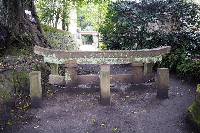
Instagram Worthiness:★★★★★
Photography Opportunity: All seasons
Location Information: ▶Map, Hours, Routes
Transportation Information: 15 minutes by ferry from Kagoshima Port ▶Timetable
Sakurajima Daikon
Sakurajima Daikon is a traditional vegetable of Kagoshima Prefecture, recognized by the Guinness Book of World Records as the world’s largest radish. Typically weighing around 6 kg, the largest ones can weigh up to 30 kg and have a diameter of 40-50 cm. Named after its specialty in Sakurajima, it is also known locally as “Shima Daikon.” The large-diameter pickled slices are especially popular as a specialty of Kagoshima Prefecture.
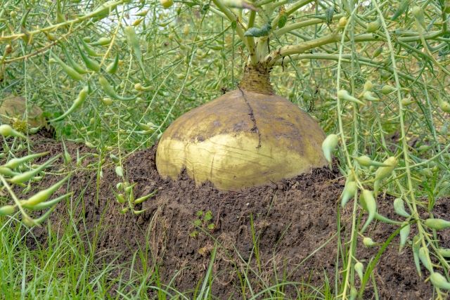
Instagram Worthiness:★★★★★
Photography Opportunity: All seasons
Location Information: ▶Map, Hours, Routes
Transportation Information: 15 minutes by ferry from Kagoshima Port ▶Timetable
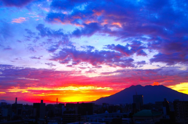
Dawn at Sakurajima
Shiroyama Park in Kagoshima City is located on a 107-meter-high hill with an observatory and walking paths. From here, you can see Sakurajima during the day, and on clear days, you can also see Kirishima and Kaimondake in Ibusuki in the distance. Known for its beautiful night views, it is also a popular spot to enjoy the mystical scenery of Sakurajima at dawn.
Instagram Worthiness:★★★★★
Photography Opportunity: All seasons
Location Information: ▶Map, Hours, Routes
Transportation Information: 4 minutes by bus from Kagoshima Station, 19 minutes on foot
Diamond Sakurajima
From late November to mid-January, you can observe a phenomenon where the sun overlaps the summit of Sakurajima. During this time, you can witness the beautiful sight of the sun shining like a diamond for about three minutes. The best time to see this is around 4:55 PM from mid to late December.

Instagram Worthiness:★★★★★
Photography Opportunity: Late November to mid-January
Location Information: ▶Map, Hours, Routes
Transportation Information: 4 minutes by bus from Kagoshima Station, 19 minutes on foot
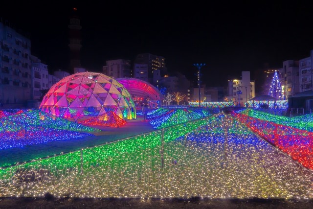
Tenmonkan
Tenmonkan, located in the center of Kagoshima City, is one of the busiest shopping districts in Kyushu. The name originates from the Edo period observatory built by the Shimazu clan of the Satsuma Domain. Tenmonkan is home to many restaurants offering Kagoshima’s local cuisine, including Kurobuta tonkatsu, Kagoshima ramen, and the famous shaved ice dessert “Shirokuma.” It is also within walking distance of tourist spots like the statue of Takamori Saigo. From December to January, Tenmonkan hosts the “Millionation,” an illumination event featuring one million LED lights, attracting many visitors.
Instagram Worthiness:★★★★★
Photography Opportunity: All seasons
Location Information: ▶Map, Hours, Routes
Transportation Information: 8 minutes by bus from Kagoshima Station
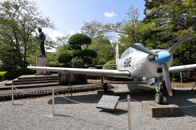
Chiran Peace Museum
Chiran, a town that hosted a special attack base of the former Japanese Army during the end of World War II, is where kamikaze pilots launched suicide attacks on enemy ships. The museum exhibits portraits, personal belongings, and fighter planes used by the pilots, aiming to convey the futility of war and promote peace and the sanctity of life.
Instagram Worthiness:★★★★★
Photography Opportunity: All seasons
Location Information: ▶Map, Hours, Routes
Transportation Information:28 minutes by bus from Nishi-Ei Station
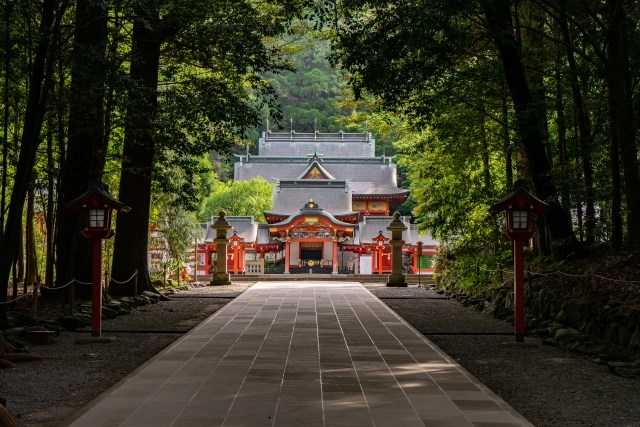
Kirishima Shrine
Located about 1 hour and 20 minutes by car from Kagoshima Chuo Station, Kirishima Shrine enshrines Ninigi-no-Mikoto, a protagonist in Japan’s founding myth. Founded in the 6th century and relocated to its current site about 500 years ago, the current shrine building was constructed in 1715 by the Shimazu clan. Over 100 rituals are held annually, with the drum performance on New Year’s Day and February 11 being particularly famous. The shrine area offers beautiful cherry blossoms in spring and vibrant autumn foliage.
Instagram Worthiness:★★★★★
Photography Opportunity: All seasons
Location Information: ▶Map, Hours, Routes
Transportation Information: Infrequent public transportation car recommended
Kagoshima Shrine
Kagoshima Shrine, the largest shrine in southern Kyushu, originally enshrines Sakurajima. The shrine building, constructed in 1756, features dragon carvings and ceiling decorations with plant paintings. The spring Hatsuuma Festival features dancing with decorated horses, while the autumn Hayato Hamaori Festival includes a warrior procession and portable shrine parade to the sea.
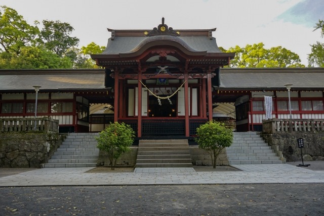
Instagram Worthiness:★★★★★
Photography Opportunity: All seasons
Location Information: ▶Map, Hours, Routes
Transportation Information: 18 minutes on foot from Hayato Station
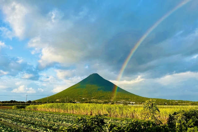
Kaimondake
Standing at 924 meters, the cone-shaped Kaimondake, also known as Satsuma Fuji, offers a 360-degree panoramic view from the summit, including Kirishima, Yakushima, and the Nansei Islands. The gentle hiking trail makes it accessible for people of all ages.
Instagram Worthiness:★★★★★
Photography Opportunity: All seasons
Location Information: ▶Map, Hours, Routes
Transportation Information: Infrequent public transportation car recommended
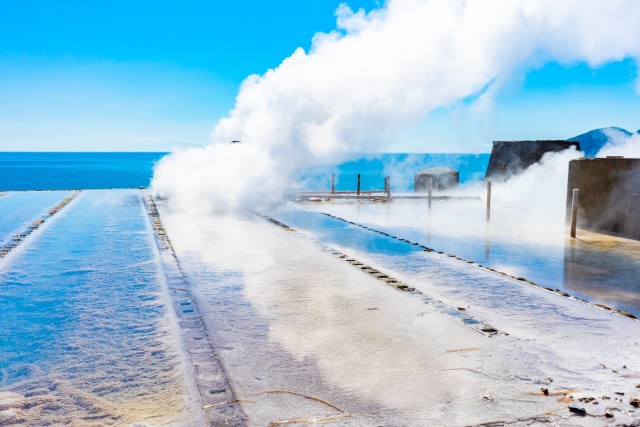
Ibusuki Onsen
Ibusuki Onsen, located on the Satsuma Peninsula, is one of Kyushu’s representative hot spring areas with over 1,000 hot spring sources. The hot spring water is rich in metasilicic acid, known for its skin-beautifying effects. Particularly noteworthy is the natural sand bath at Surigahama, where you bury yourself in sand heated by hot spring water, a unique experience with a 300-year history. Scientifically proven benefits attract many domestic and international tourists.
Instagram Worthiness:★★★★★
Photography Opportunity: All seasons
Location Information: ▶Map, Hours, Routes
Transportation Information:1 minute on foot from Ibusuki Station
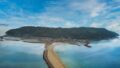
Tanegashima
Tanegashima is historically significant as the site where firearms were first introduced to Japan by the Portuguese. It is now also known as the island closest to space, home to Japan’s only operational satellite launch facility, Tanegashima Space Center. The Tanegashima Museum exhibits firearms brought by the Portuguese, allowing visitors to deeply appreciate the history of firearms in Japan. The island also boasts beautiful beaches and mangrove forests, offering various marine sports, including scuba diving.
Instagram Worthiness:★★★★★
Photography Opportunity: All seasons
Location Information: ▶Map, Hours, Routes
Transportation Information: Tanegashima Airport▶Timetable
Amami Oshima
Amami Oshima, located between Okinawa and Kyushu, is the second-largest island in Japan after Sado Island. Often called the “Galapagos of the East,” it boasts lush forests thanks to its abundant water resources and fertile soil. The island is famous for its mangrove forest, the second largest in Japan, with a unique ecosystem. One of the highlights is the “Kuroshio Forest Mangrove Park,” where you can experience the mangrove forest by canoe. Additionally, every winter, humpback whales come to the island’s waters for breeding and raising their young. Whale watching tours offer a close-up view of these magnificent creatures.
Instagram Worthiness:★★★★★
Photography Opportunity: All seasons
Location Information: ▶Map, Hours, Routes
Transportation Information: Amami Airport ▶Timetable
Kakeroma Island
Kakeroma Island is located about 20 minutes by boat from Amami Oshima’s port. The island is elongated east to west, with a circumference of about 150 km. It offers a tranquil atmosphere, with cats lazing around and the sound of waves, providing a more remote island feel than Amami Oshima. A must-see spot on Kakeroma Island is the 700-year-old giant tree known as Osai’s Banyan Tree, located in the southern part of the island.
Instagram Worthiness:★★★★★
Photography Opportunity: All seasons
Location Information: ▶Map, Hours, Routes
Transportation Information: 20 minutes by ferry from Amami Oshima
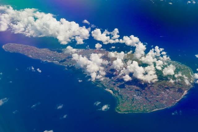
Tokunoshima
Tokunoshima, located southwest of Amami Oshima, has an area of about 248 square kilometers and a circumference of about 80 km. In 2021, it was registered as a World Natural Heritage site along with Amami Oshima. It is known for bullfighting, with three annual bullfighting tournaments being one of the island’s highlights. The island is also famous for its high birth rate, being known as the “Island of Fertility.” The beautiful sunset view from “Megane Rock,” a natural arch formed by uplifted coral reefs, is a must-see.
Instagram Worthiness:★★★★★
Photography Opportunity: All seasons
Location Information: ▶Map, Hours, Routes
Transportation Information: Tokunoshima Airport ▶Timetable
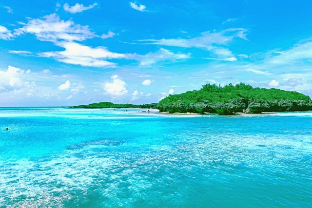
Yoron Island
Yoron Island is located about 23 km from Okinawa’s main island. The island has been influenced by both Satsuma and Ryukyu cultures, fostering a unique traditional performing arts scene. Surrounded by clear, beautiful seas, it boasts over 60 white sandy beaches. One of the most famous spots is Yurigahama, a “phantom beach” that appears only during low tide and is considered one of the most beautiful spots on the island.
Instagram Worthiness:★★★★★
Photography Opportunity: All seasons
Location Information: ▶Map, Hours, Routes
Transportation Information: Yoron Airport▶Timetable
Okinoerabu Island
Okinoerabu Island, located 552 km south of Kagoshima and about 60 km north of Okinawa’s main island, has a unique culture blending Ryukyu and Satsuma influences. The island, formed by uplifted coral reefs, is known for its ocarina-like shape and was listed in the Michelin Green Guide Japan in 2017. It is also known as a filming location for dramas and movies. With an average annual temperature of 22°C, it features a beautiful environment where subtropical flowers bloom year-round. Additionally, over 300 limestone caves are scattered across the island, making it known as the “Island of Flowers and Limestone Caves.”
Instagram Worthiness:★★★★★
Photography Opportunity: All seasons
Location Information: ▶Map, Hours, Routes
Transportation Information: Okinoerabu Airport ▶Timetable
Yakushima
Yakushima is enveloped in ancient, grand nature, home to many endemic and endangered species of flora and fauna, including the millennium-old Yakusugi cedar. The island is characterized by its unique ecosystem, ranging from subtropical to subalpine vertical distribution from the coast to the center. These features earned it recognition as Japan’s first World Natural Heritage site in 1993.
Instagram Worthiness:★★★★★
Photography Opportunity: All seasons
Location Information: ▶Map, Hours, Routes
Transportation Information: 2 hours by ferry from Kagoshima Port▶Timetable
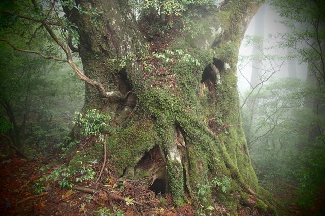
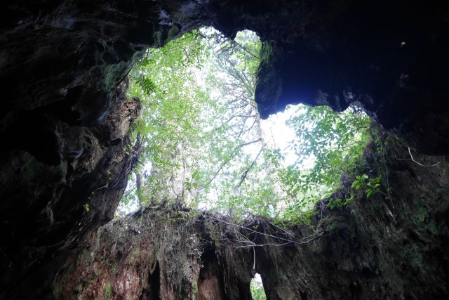
Jomon Sugi
In Yakushima’s forest, the cedar forest expands above an altitude of 500 meters. Especially, cedars over 1,000 years old are called “Yakusugi.” Among them, Jomon Sugi is particularly famous, known as the largest cedar in Yakushima, with an estimated age of between 2,000 and 7,200 years, leaving visitors in awe.
Instagram Worthiness:★★★★★
Photography Opportunity: All seasons
Location Information: ▶Map, Hours, Routes
Transportation Information: Infrequent public transportation car recommended
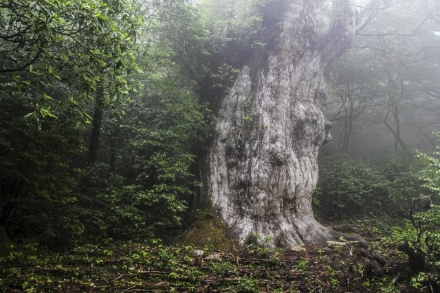
Wilson Stump
Wilson Stump is said to be the stump of a huge Yakusugi felled about 400 years ago. Inside the stump is a large hollow with a clear spring flowing from it. At the base, three small cedars grow, showing the cycle of new life following the felled giant tree. The name derives from Dr. Wilson, an American botanist who conducted research on Yakusugi and introduced this large stump to the world in the Taisho era.
Instagram Worthiness:★★★★★
Photography Opportunity: All seasons
Location Information: ▶Map, Hours, Routes
Transportation Information: Infrequent public transportation car recommended
Shiratani Unsuikyo
Shiratani Unsuikyo is a popular spot where you can easily appreciate Yakushima’s primeval forest, including Yakusugi over 1,000 years old. Particularly in spring, the mountain cherry blossoms and fresh greenery, along with panoramic views of Kyushu’s highest peak, Miyanoura-dake, provide a refreshing landscape that will make you forget the fatigue of climbing.
Instagram Worthiness:★★★★★
Photography Opportunity: All seasons
Location Information: ▶Map, Hours, Routes
Transportation Information: Infrequent public transportation car recommended
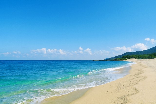
Nagata Inakahama
Nagata Inakahama is a beach formed by the white sand carried by weathered granite from the Nagata River, stretching for 800 meters. It is known as a nesting site for sea turtles that swim across the Pacific Ocean. However, during the sea turtle nesting and hatching season (from May 1 to August 31), access to the beach is restricted at night (from 7:30 PM to 5:00 AM the next morning).
Instagram Worthiness:★★★★★
Photography Opportunity: All seasons
Location Information: ▶Map, Hours, Routes
Transportation Information: Infrequent public transportation car recommended
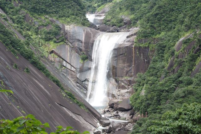
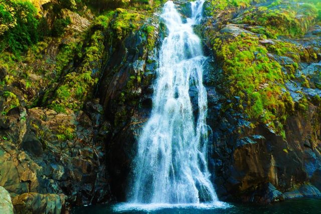
Senjin Falls
With a drop of about 60 meters, Senpiro Falls is one of the beautiful landscapes representing Yakushima, where a large amount of water cascades down. The abundant rainfall in Yakushima creates a river that carves out the giant granite rock, offering a magnificent view.
Instagram Worthiness:★★★★★
Photography Opportunity: All seasons
Location Information: ▶Map, Hours, Routes
Transportation Information: Infrequent public transportation car recommended
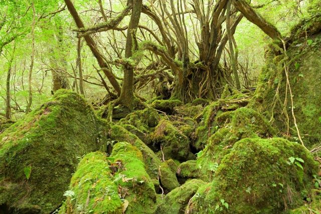
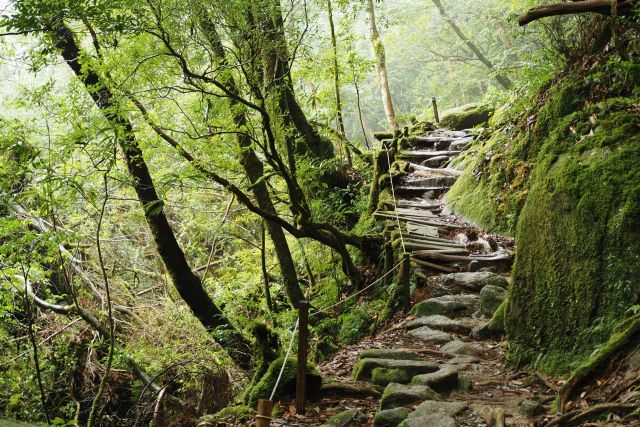
Forest of Princess Mononoke
Yakushima is said to be the inspiration for the forest in Studio Ghibli’s movie “Princess Mononoke.” Particularly famous is the “Moss-covered Forest,” with its deep green primeval forest where trees and rocks are covered in moss, creating a fantastical landscape. It is possible to explore individually without a guide.
Instagram Worthiness:★★★★★
Photography Opportunity: All seasons
Location Information: ▶Map, Hours, Routes
Transportation Information: Infrequent public transportation car recommended
Okawa Falls
Okawa Falls, standing at 88 meters high, showcases a powerful sight with a large volume of water cascading down a cliff. Visitors can walk up to the waterfall basin and feel the splash of water up close.
Instagram Worthiness:★★★★★
Photography Opportunity: All seasons
Location Information: ▶Map, Hours, Routes
Transportation Information: Infrequent public transportation car recommended