Introducing Instagram-Worthy Photos of Kumamoto Prefecture
Kumamoto Prefecture is blessed with attractive tourist spots such as the historically valuable Kumamoto Castle and Suizenji Jojuen Garden, the popular Kurokawa Onsen with its modern style, Sakitsu Village registered as a World Heritage Site, and Mount Aso, which has one of the largest calderas in the world.
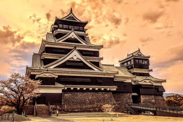
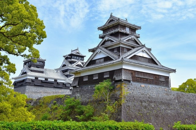
Kumamoto Castle
Kumamoto Castle is one of the most famous castles in Japan, comparable to Nagoya Castle and Osaka Castle as an important historical structure. It was built by Kato Kiyomasa, the feudal lord of Higo (modern-day Kumamoto Prefecture), and completed in 1607. The castle is known for its vast grounds (approximately 98 hectares in total area) and its unique construction techniques that utilize stone walls and natural terrain. During the Satsuma Rebellion of 1877, Kumamoto Castle experienced a siege that lasted about 50 days, showcasing its formidable defenses. However, it suffered significant damage and was burned down after the battle. The current main keep visible today was reconstructed in 1960. The castle was once again damaged by the Kumamoto earthquake in 2016, and restoration work is currently ongoing.
Instagram Worthiness:★★★★★
Photography Opportunity: All seasons
Location Information: ▶Map, Hours, Routes
Transportation Information: 7-minute bus ride from Kumamoto Station
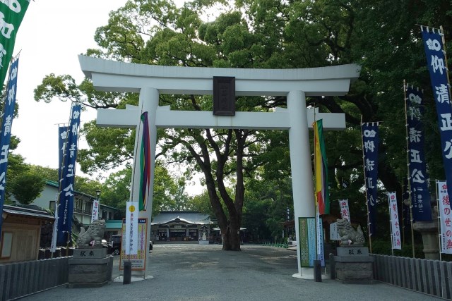
Kato Shrine
This shrine, dedicated to Lord Kato Kiyomasa, is located just a few minutes’ walk from Kumamoto Castle. The shrine honors Kato Kiyomasa, a notable samurai of the Sengoku period, as its primary deity. From the shrine grounds, visitors can get a close view of Kumamoto Castle, and it also displays a stone inscribed with a Kannon image discovered from the collapsed stone walls.
Instagram Worthiness:★★★★★
Photography Opportunity: All seasons
Location Information: ▶Map, Hours, Routes
Transportation Information: 16-minute bus ride from Kumamoto Station
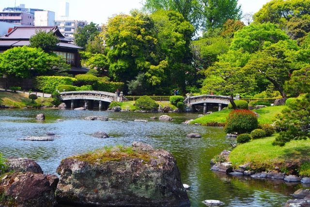
Suizenji Jojuen Garden
Jojuen Garden began in 1632 with the construction of a teahouse by Hosokawa Tadatoshi, the first lord of the Higo Hosokawa clan. The garden was completed during the era of the third lord, Hosokawa Mitsunao. Within the garden, there is Izumi Shrine, which enshrines successive lords of the Hosokawa clan, and a Noh stage relocated from the Kyoto Imperial Palace in 1912 stands by the pond. In late March to early April, cherry blossoms bloom along the garden’s walking paths, attracting many visitors for hanami (flower viewing).
Instagram Worthiness:★★★★★
Photography Opportunity: All seasons
Location Information: ▶Map, Hours, Routes
Transportation Information: 11-minute walk from Shin-Suizenji Station
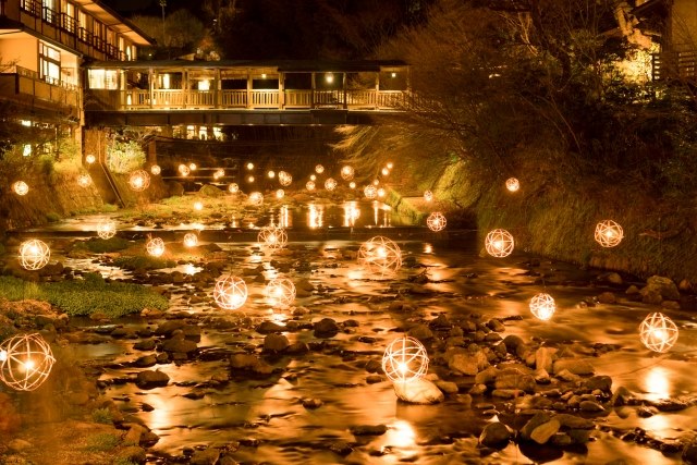
Kurokawa Onsen
Kurokawa Onsen, popular nationwide, features about 30 inns, with the entire area considered one large ryokan (Japanese inn). Each inn functions as a separate annex, and the paths connecting them are seen as corridors. This approach of treating the whole hot spring town as a unified hospitality space is distinctive. Each inn also has its unique hot spring source, offering different water qualities. There are onsen sommeliers available, providing tips for enjoying the baths that benefit the skin.
Instagram Worthiness:★★★★★
Photography Opportunity: All seasons
Location Information: ▶Map, Hours, Routes
Transportation Information: 1-hour 37-minute bus ride from Higo-Ozu Station
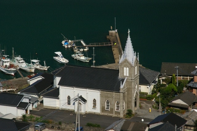
Sakitsu Church
The Sakitsu Village, registered as a World Heritage Site in 2018, is a fishing village that nurtured a unique form of faith during the period of Christianity prohibition, blending Buddhism, Shintoism, and Christianity. Jesuit missionary Almeida began spreading Christianity in 1569, and many villagers became Christians. The village is dotted with sites such as a shrine where hidden Christians prayed, a Gothic-style church, and a maritime Madonna statue, reflecting a long history of unique faith and prayer. Sakitsu Church, the central religious facility in the village, was completed in 1888 beneath the Sakitsu Suwa Shrine. This Gothic-style church, illuminated by vivid stained glass, creates a serene space.
Instagram Worthiness:★★★★★
Photography Opportunity: All seasons
Location Information: ▶Map, Hours, Routes
Transportation Information: Infrequent public transportation car recommended
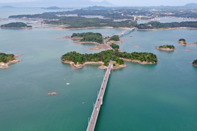
Amakusa Gokyo (Amakusa Five Bridges)
The 12 km long series of five bridges connecting mainland Kyushu to the Amakusa Islands is affectionately known as the “Amakusa Pearl Line.” This popular drive route features bridges designed by different engineers, each with its unique appearance and structure. The bridge group is also a popular photo spot, offering various ways to enjoy the scenery.
Instagram Worthiness:★★★★★
Photography Opportunity: All seasons
Location Information: ▶Map, Hours, Routes
Transportation Information: 20-minute walk from Misumi Station
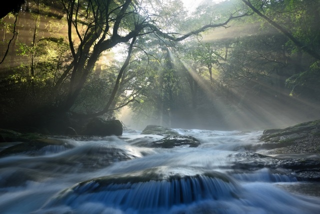
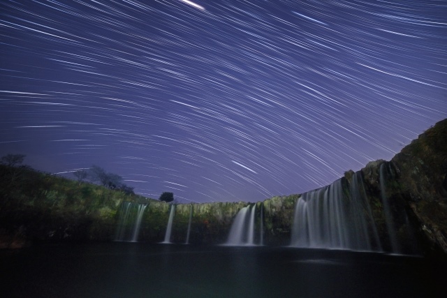
Kikuchi Gorge
Kikuchi Gorge, formed by groundwater flowing from the outer rim of Mount Aso, creates a varied landscape with numerous rapids, pools, and waterfalls. With an average summer water temperature of 13 degrees Celsius, it is known as a natural cooler and is a popular summer retreat. In spring, fresh green leaves are beautiful, in autumn, the mountains are colored with vibrant foliage, and in winter, the gorge is adorned with frost flowers, offering stunning scenery throughout the year.
Instagram Worthiness:★★★★★
Photography Opportunity: All seasons
Location Information: ▶Map, Hours, Routes
Transportation Information: Infrequent public transportation car recommended
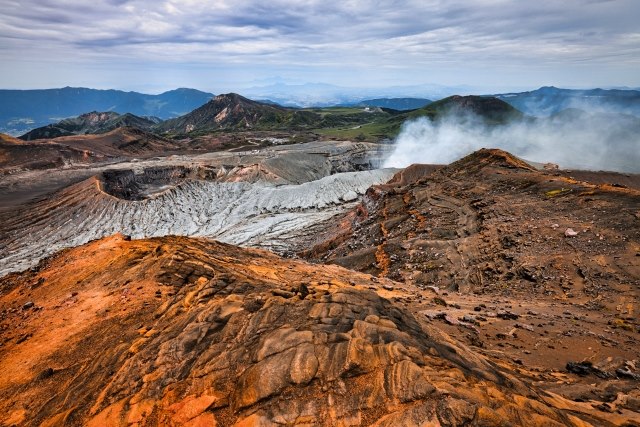
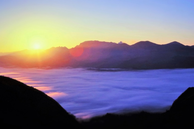
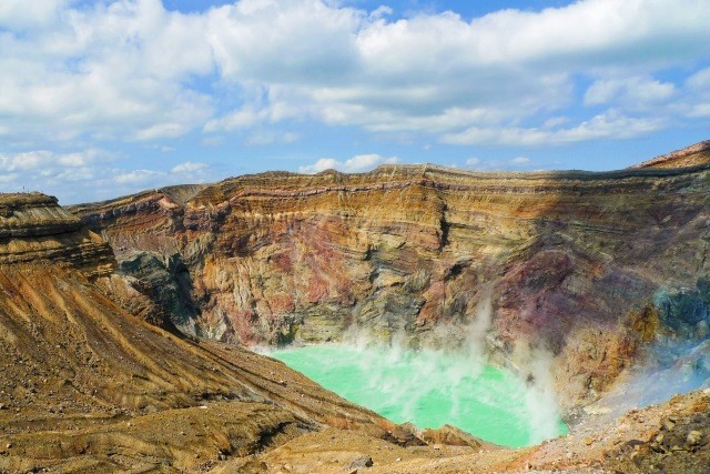
Mount Aso
Mount Aso, an active volcano with one of the largest calderas in the world, was formed by a massive eruption approximately 100,000 years ago. It has five main peaks: Takadake, Nakadake, Nekodake, Eboshidake, and Kishimadake. The highest peak, Takadake, stands at 1,592 meters. Visitors can drive close to the crater, where the sight of steam rising from the ground offers a powerful reminder of nature’s force.
Instagram Worthiness:★★★★★
Photography Opportunity:Spring, Summer, Autumn / Partial closure in winter
Location Information: ▶Map, Hours, Routes
Transportation Information: 40-minute bus ride from Aso Station
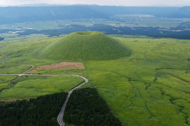
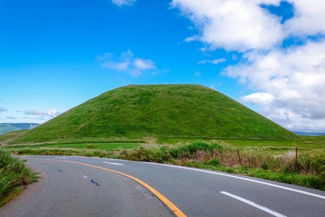
Komezuka
Komezuka, standing about 80 meters tall, is characterized by its unique terrain formed by an eruption around 3,300 years ago. Its shape resembles an inverted bowl, with a large depression at the summit. There is a legend that Komezuka was formed by rice piled up by the deity of Aso Shrine. This mystical landscape, combining clouds and Komezuka, is truly spectacular.
Instagram Worthiness:★★★★★
Photography Opportunity: All seasons
Location Information: ▶Map, Hours, Routes
Transportation Information: Infrequent public transportation car recommended
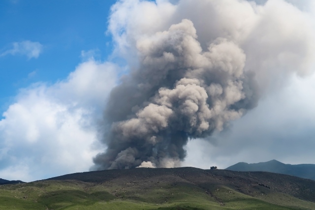
Mount Aso Crater
Mount Aso is also an important site for volcanic research, with constant monitoring of its volcanic activity. In recent years, volcanic activity has sometimes intensified, leading to restrictions on climbing and sightseeing. It is recommended to check the latest information before visiting.
Instagram Worthiness:★★★★★
Photography Opportunity: Spring, Summer, Autumn / Partial closure in winter
Location Information: ▶Map, Hours, Routes
Transportation Information: 40-minute bus ride from Aso Station
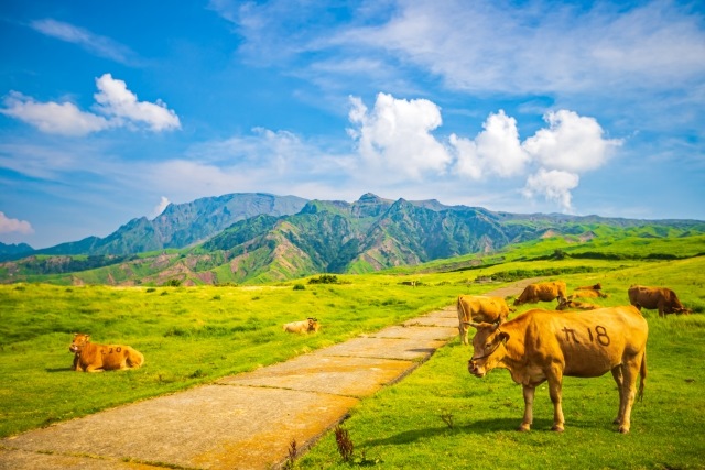
Aso Panorama Line
The Aso Panorama Line is a general term for the mountain roads leading to Mount Aso in Kumamoto Prefecture, stretching from the center of the Aso caldera to the summit. This road offers stunning views of the grasslands, the smoking Nakadake, and the outer rim mountains surrounding the caldera. Along the way, vast pastures spread out, where cattle and horses graze. Further along, you will find Kusasenrigahama and the Aso Ropeway entrance to the Aso crater.
Instagram Worthiness:★★★★★
Photography Opportunity: All seasons
Location Information: ▶Map, Hours, Routes
Transportation Information: Infrequent public transportation car recommended
