Introducing Instagram-Worthy Photos of Miyazaki Prefecture
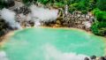
Miyazaki Prefecture is also known as the land of myths, and it is dotted with many historical sites. Notable examples include the Saitobaru Burial Mounds from the Kofun period, Amano Iwato Shrine, Udo Shrine, Aoshima Shrine, and Miyazaki Shrine. Additionally, the mystical and beautiful Takachiho Gorge is one of the most prominent photography spots in Kyushu.
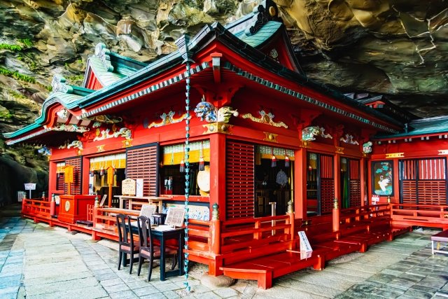
Udo Shrine
Located in Nichinan City, Miyazaki Prefecture, Udo Shrine is set halfway up a cliff facing the Hyuga Sea, with the main shrine built inside a cave measuring 38 meters east to west, 29 meters north to south, and 8.5 meters high. Unlike other shrines where you climb stairs to worship, this shrine has a unique structure that requires descending stone steps along the cliff to reach the main shrine. It is known for attracting many visitors who come to pray for marriage, safe childbirth, and child-rearing.
Instagram Worthiness:★★★★★
Photography Opportunity: All seasons
Location Information: ▶Map, Hours, Routes
Transportation Information: 59 minutes by bus from Miyazaki Airport Station, 24-minute walk
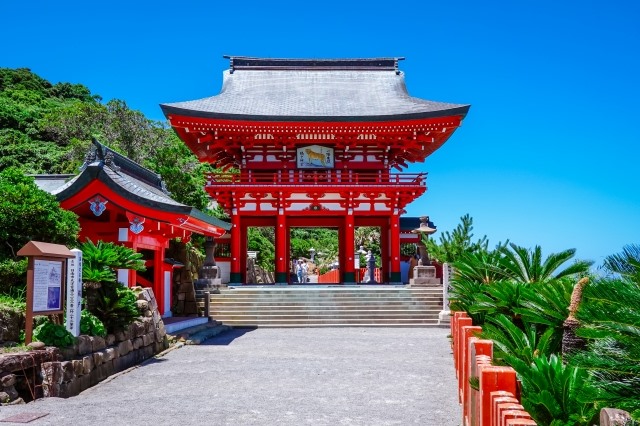
Aoshima Shrine
Aoshima Shrine is located in the center of Aoshima, surrounded by subtropical plants. The shrine’s bright vermilion color stands out against the blue sky. This shrine is believed to be particularly beneficial for matchmaking because it is where the gods from mythology were united. The grounds are filled with heart-shaped ema (votive plaques) and objects related to love fulfillment, and it is popular to search for the “boar’s eye” that appears heart-shaped.
Instagram Worthiness:★★★★★
Photography Opportunity: All seasons
Location Information: ▶Map, Hours, Routes
Transportation Information: 5-minute walk from Aoshima Station
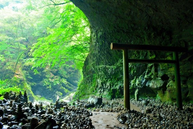
Amano Iwato Shrine
Located in Takachiho Town, Amano Iwato Shrine is dedicated to the cave where the sun goddess Amaterasu Omikami hid according to Japanese mythology. The shrine consists of two main shrines, the Western Shrine and the Eastern Shrine, both dedicated to Amaterasu Omikami. About a 10-minute walk from Amano Iwato Shrine is Amanoyasugawara, a historic site where it is said that the gods gathered to discuss when Amaterasu hid in the cave. This area has a cave called Yambogutsu, 40 meters wide, with a torii gate and shrine inside. However, access may be restricted during heavy rain when the river water rises.
Instagram Worthiness:★★★★★
Photography Opportunity: All seasons
Location Information: ▶Map, Hours, Routes
Transportation Information: 1 hour 20 minutes by bus from Nobeoka Station
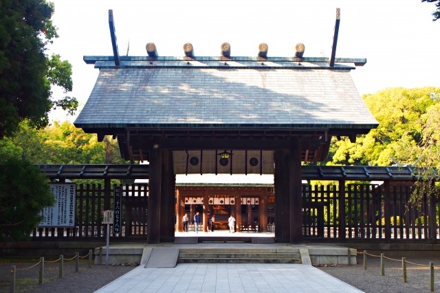
Miyazaki Shrine
Miyazaki Shrine is dedicated to Japan’s first emperor, Emperor Jimmu, and is believed to bring blessings for family safety, marital harmony, safe childbirth, childbearing, victory in battle, and success in exams. The lantern-lit approach creates a mystical atmosphere, offering visitors a sense of spiritual purification. The current shrine building was constructed in 1907. The Miyazaki Shrine Festival, which features a solemn procession dedicated to Emperor Jimmu, is a highlight, and various traditional events are held throughout the year, such as festivals praying for a good harvest and thrilling horseback archery.
Instagram Worthiness:★★★★★
Photography Opportunity: All seasons
Location Information: ▶Map, Hours, Routes
Transportation Information: 12 minutes by bus from Miyazaki Station
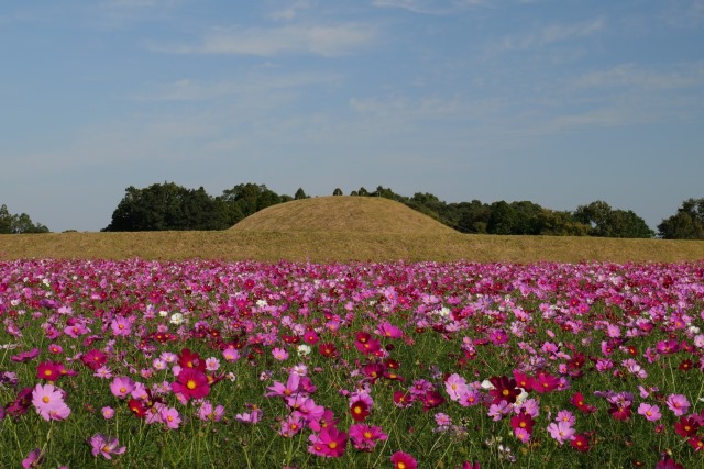
Saitobaru Burial Mounds
The Saitobaru Burial Mounds, spanning 2.6 km east to west and 4.2 km north to south, comprise one of Japan’s largest groups of burial mounds, with over 300 mounds of various shapes and sizes. The male and female burial mounds, in particular, are well-known but managed by the Imperial Household Agency and are off-limits to the public. In spring, the area is adorned with 300,000 rapeseed flowers and 2,000 cherry blossoms, attracting many tourists.
Instagram Worthiness:★★★★★
Photography Opportunity: All seasons
Location Information: ▶Map, Hours, Routes
Transportation Information: 26 minutes by bus from Sadowara Station, 34-minute walk
Cape Toi
Cape Toi, part of the Nichinan Coast, is a cape projecting into the Pacific Ocean, surrounded by cliffs ranging from 10 to 50 meters high. It is known as the habitat of the wild horses called Misaki horses, a natural monument and a rare sight globally. These horses are said to have descended from the samurai horses of the Edo period that became feral. The cape features the Cape Toi Visitor Center, Cape Toi Lighthouse, Misaki Shrine, and well-maintained walking trails. There are also guided tours to observe the wild horse society up close.
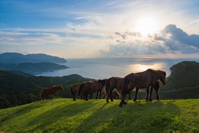
Instagram Worthiness:★★★★★
Photography Opportunity: All seasons
Location Information: ▶Map, Hours, Routes
Transportation Information: 38 minutes by bus from Kushima Station
Nichinan Coast
The coastline around Aoshima on the Nichinan Coast features unique wave-shaped rocks called the Devil’s Washboard. These rocks were formed approximately 7 million years ago by the alternating deposition of hard sandstone and soft mudstone in the sea, which then rose to the surface. Over time, waves washed away the softer mudstone layers, leaving behind the hardened sandstone layers stacked like boards. These wave-shaped rocks can be seen along the coastline for about 8 km from Aoshima to Kinchaku Island to the south. During low tide, visitors can enjoy exploring the tide pools.
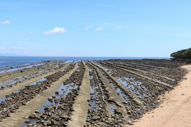
Instagram Worthiness:★★★★★
Photography Opportunity: All seasons
Location Information: ▶Map, Hours, Routes
Transportation Information: 60 minutes by bus from Miyazaki Station
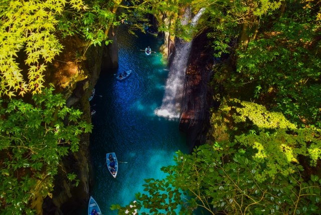
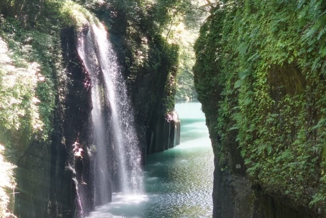
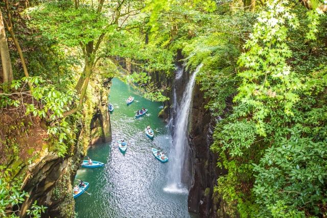
Takachiho Gorge
Takachiho Gorge, with its vertical rock walls, has the Gokase River flowing quietly at the bottom and the magnificent 17-meter Manai Falls surrounded by lush greenery. The scenery is divine, befitting the name of Takachiho, the “Land of the Gods.” Walking trails are maintained along the gorge, and it is recommended to walk all the way to Takachiho Bridge, where you can view the three bridges of different eras and heights: Shinbashi, Takachiho Bridge, and Kamito Takachiho Bridge. The changing gorge beauty is also enjoyable.
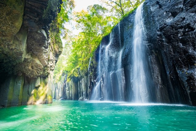
Instagram Worthiness:★★★★★
Photography Opportunity: All seasons
Location Information: ▶Map, Hours, Routes
Transportation Information: 1 hour 20 minutes by bus from Nobeoka Station, 25-minute walk
Manai Falls
The main feature of Takachiho Gorge, Manai Falls, has been selected as one of Japan’s Top 100 Waterfalls, with water falling from a height of about 17 meters, creating a spectacular sight. In summer, the falls are illuminated, offering a mystical and beautiful view. The walking trail has observation decks from which you can look down at the falls, and there are also popular boat rentals, allowing you to enjoy the view from below.
Instagram Worthiness:★★★★★
Photography Opportunity: All seasons
Location Information: ▶Map, Hours, Routes
Transportation Information: 1 hour 20 minutes by bus from Nobeoka Station, 24-minute walk
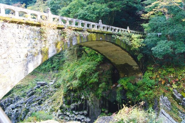
The Three Bridges of Takachiho Gorge
Takachiho Gorge features three bridges. From bottom to top: Shinbashi (a stone bridge), Takachiho Bridge (a steel bridge), and Kamito Takachiho Bridge (a concrete bridge). The view of these three bridges is breathtaking.
Instagram Worthiness:★★★★★
Photography Opportunity: All seasons
Location Information: ▶Map, Hours, Routes
Transportation Information: 1 hour 20 minutes by bus from Nobeoka Station, 24-minute walk
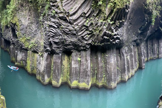
Columnar Joints of Takachiho Gorge
The unique rock formations that shape the beauty of the gorge were created by the erosion of pyroclastic flows from ancient eruptions of Mount Aso over a long period. The gorge can be enjoyed year-round, with different expressions in spring with fresh greenery, summer when illuminated, colorful autumn foliage, and snow in winter.
Instagram Worthiness:★★★★★
Photography Opportunity: All seasons
Location Information: ▶Map, Hours, Routes
Transportation Information: 1 hour 20 minutes by bus from Nobeoka Station, 25-minute walk
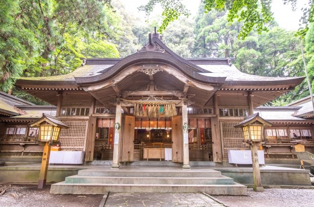
Takachiho Shrine
Well-maintained walking trails allow visitors to enjoy nature at a leisurely pace. Nearby is Takachiho Shrine, where visitors can learn about the myths and history of Miyazaki Prefecture. Takachiho Gorge offers a variety of landscapes and experiences each visit, making it a recommended destination for nature lovers, photography enthusiasts, and those interested in history and culture.
Instagram Worthiness:★★★★★
Photography Opportunity: All seasons
Location Information: ▶Map, Hours, Routes
Transportation Information: 1 hour 20 minutes by bus from Nobeoka Station, 11-minute walk